
Roman Empire Map
High quality vector map of Roman Empire (dimensions 65×68 cm). All elements of the map are layered and organized by folder structure, so you can customize them however you want; change colors of the different objects or elements, resize the objects or shapes, turn off or on layers…
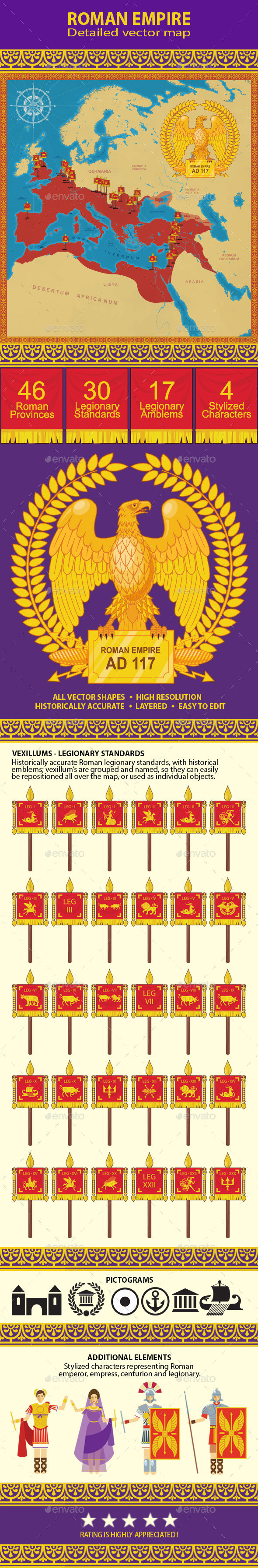
Relevant historical sources were used to produce the Roman Empire Map, and it is historically accurate. The map was created with educational purposes in mind, but can be used as you wish.
The Roman Empire Map contains several layers (divided by the topic) and by turning the layers off or on you can produce several different Roman Empire Maps with different topics (military, politics, trade…)
THE MAP INCLUDES
- General map of the Roman Empire at it’s height (117 AD)
- 46 Roman provinces, listed by name, and layered as individual objects or groups, with provincial capitals
- Vassal states, politically dependent on the Roman Empire (117 AD)
- Map of the sea trade with important sea ports
- Map of the legionary camps (with legionary standards) and important naval bases
THE PACKAGE CONTAINS
- Roman Empire maps
- Set of Roman legionary standards (vexillums)
- Set of heraldic emblems used by the legionaries
- Pictograms: navy, capital, important city
- Large emblem of the Imperial Roman Eagle
- Compass rose
- Several Roman characters: emperor, empress, centurion and legionary
- Several historically accurate Roman ornaments (tillable)